

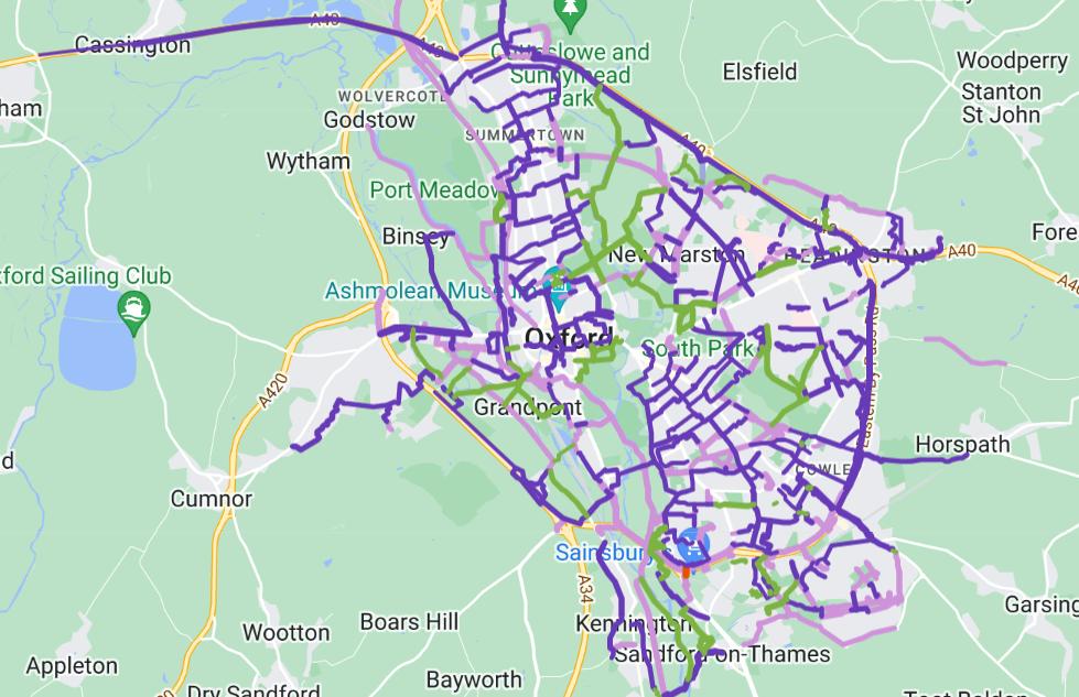

An online map showing low-traffic cycle routes in Oxford has been launched after a crowdsourcing effort.
The Oxford Online Cycle Map shows routes that are car-free, protected or low-traffic, and walking-only, and reveals the location of road crossings.
It was developed by cycling enthusiasts - including Tom Green, Emily Kerr, Hannah Kirby and Danny Yee – and came out of conversations with schoolchildren and older cyclists.
READ MORE: Lack of transport plan for thousands of new homes 'depressing', says rail campaigner
Emily Kerr, a Green Party councillor on Oxford City Council, said: “The Oxford Online Cycle Map has been an absolute labour of love for a number of us.
“I'm so very proud of it and would love to share it with you and for you to share it if useful.”

She said the map developed through conversations with Oxford residents who ‘didn't know where they could cycle safely outside of their local areas.’
READ MORE: Severe delays after Oxford crash on Abingdon Road
Cllr Kerr and others initially started a shared Google Maps to mark low traffic routes across the city to help people cycle safely.
Over time, people from across the city began to contribute to the map.
The Oxford Online Cycle Map has been an absolute labour of love for a number of us.
— Cllr Emily Kerr 💚 (@EmilyKerr36) May 29, 2023
I'm so very proud of it and would love to share it with you and for you to share it if useful.
Here's some more about it, a 🧵🪡 https://t.co/tNYLMH6ckn
A crowdsourcing effort led to the launch of the online map – which focuses specifically on routes nearby to crossings.
Cllr Kerr said: “One of the most fun things for me has been how people have just got on and contributed, working together remotely, without anyone really managing the process.
“Anyway, I hope you all like it and it's useful for you or people you know who want to cycle in Oxford.”
To access the map, visit: https://www.cyclox.org/index.php/2023/05/28/oxford-online-cycle-map/


Comments: Our rules
We want our comments to be a lively and valuable part of our community - a place where readers can debate and engage with the most important local issues. The ability to comment on our stories is a privilege, not a right, however, and that privilege may be withdrawn if it is abused or misused.
Please report any comments that break our rules.
Read the rules hereLast Updated:
Report this comment Cancel