
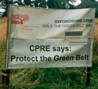
It might come as a surprise to some people that the creation last year of the Oxford Green Belt Way was the brainchild of the Oxfordshire Branch of the Campaign to Protect Rural England.
CPRE is perhaps better known for its campaigning against damaging development in the countryside, and not so much as an organisation that promotes walking for people to enjoy the beauty, tranquillity and diversity of the English countryside.
But, in fact, CPRE Oxfordshire has a long tradition of not only protecting the county's rights of way, but also of establishing long distance walks across the county.
In the late 1970s the branch helped to organise a series of Save the Countryside' sponsored walks, and in 1976 was instrumental in the creation of the Oxfordshire Way, linking from west to east two Areas of Outstanding Natural Beauty, the Cotswolds and the Chilterns.
Some ten years later, through the combined efforts of CPRE Oxfordshire and the Oxford Fieldpaths Society, the d'Arcy Dalton Way was established to link from north to south other long distance walks in the county, such as the Ridgeway and Thames Path.
This was named after Colonel d'Arcy Dalton, who was chairman of CPRE's rights of way committee for many years.
So it was natural that when ideas were being proposed to celebrate the 75th anniversary of CPRE Oxfordshire, creating another walk should be suggested.
But what type of walk? A series of short walks, another linear walk, or a walk to draw attention to a current threat to Oxfordshire's countryside - the proposed development on parts of Oxford's Green Belt?
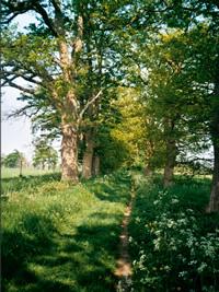
A circular walk in the Oxford Green Belt was finally proposed - circular because such a walk has the attraction of finishing where it starts and it would encompass the remarkable diversity of Oxfordshire's countryside. It would also celebrate another anniversary - 50 years of Oxford's Green Belt.
A small group was formed at the start of 2006 to devise a suitable route. The group included Gordon Garraway, David Godfrey and Nick Moon, whose encyclopedic knowledge of the county's rights of way proved invaluable.
Alun Jones, who had drawn the maps for the Save the Countyside' walks and the first map of the Oxfordshire Way, also gave the group the benefit of his professional cartographic expertise and deep historical knowledge, and Alan Spicer contributed notes on local wildlife.
As well as deciding that it should be a circular walk in the Green Belt, the group felt that it should be a walk to be enjoyed by people of all ages and walking ability and therefore based on certain criteria.
It should follow only public rights of way and it should be clearly signed with its own distinctive waymarks to make it easy to follow.
It should avoid hazardous road crossings; it should be capable of being walked in easy stages and each stage should be accessible by public transport.
And, finally, to complete the project, an easy to follow guidebook should be produced.
For the next 18 months there was much studying of maps and walking of footpaths to find a route that would satisfy these criteria and bring out attractive landscape and historical features and include areas of wildlife interest.
The aim of access by public transport was quickly settled by including links to four of the park and ride sites around the city, and making the start and finish of each stage where there was a regular bus service.
From the outset the county council's countryside services department responsible for rights of way was kept informed, and the route gained much from its advice.
By the beginning of 2007 the Green Belt Way, totalling some 50 miles, had been walked and waymarked and a leaflet giving a map of the route produced to publicise the project.
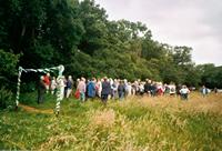
At the same time it was decided that the Oxford Green Belt Way should be launched at a public event and, since a sizeable part of it runs through his constituency, it was officially opened in July 2007 by Boris Johnson at a gathering of walkers on Shotover Plain.
Much thought and work went into the pocket-sized guidebook and no one should have any difficulty finding their way.
Starting from the Thornhill park and ride, the nine stages are set out in detail with route maps based on OS maps supplemented by detailed directions, and notes are included on the historical features and wildlife to be seen along each stage.
The Oxford Green Belt Way guidebook is published by CPRE Oxfordshire and is available at the Tourist Information Centres in Oxford, Abingdon and Woodstock, and reputable bookshops.
To purchase a copy from CPRE Oxfordshire please send a cheque or postal order for £6 (£5 plus £1 p&p) to: CPRE Oxfordshire, Punches Barn, Waterperry Road, Holton, Oxfordshire OX33 1PP. Further information on: 01865 874780 or e-mail: administrator@cpreoxon.org.uk or visit the website: www.cpregreenbeltway.org.uk


Comments: Our rules
We want our comments to be a lively and valuable part of our community - a place where readers can debate and engage with the most important local issues. The ability to comment on our stories is a privilege, not a right, however, and that privilege may be withdrawn if it is abused or misused.
Please report any comments that break our rules.
Read the rules hereComments are closed on this article