

WORK on a £150m flood defence scheme to protect western areas of Oxford start again by the end of the year.
The Oxford Flood Alleviation Scheme is a plan to create a new stream in the floodplain, which would protect areas like Botley Road, Abingdon Road and South Hinksey from flooding.
A planning application to get the scheme off the ground is due to be submitted later this year, after the works were delayed so a new bridge could be built on the southern section of the Oxford ring road.
ALSO READ: Everything we know about Oxfordshire's giant new water park Great Wolf Lodge
Ahead of that, the consortium which is running the scheme has started to ask members of the public what they think about the plans, which have been changed slightly.
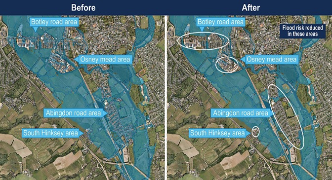
Before and after: How the scheme would protect areas of Oxford at risk of flooding. Picture: Environment Agency
Jo Emberson Wines, project director of the scheme with the Environment Agency, said: "The changes we are talking about this spring are relatively small in comparison with the whole scheme."
"The OFAS is a very important project for the people who live and work and study in Oxford. Floods can be highly destructive and disruptive to people's lives and can cause a great deal of anxiety."
She added: "Creating a scheme that reduces that risk of flooding for people is really important for the lives, livelihoods and wellbeing of the people of Oxford."
Work on the Kennington Rail Bridge on the south of the Oxford ring road delayed the flood scheme last year, and meant a planning application for it had to be withdrawn.
At the time, the Environment Agency said work on the flood scheme may not be finished until 2025.
Once complete, it is hoped the scheme will protect areas which have experienced winter flooding in recent years, including Botley Road, Abingdon Road, South Hinksey, and Osney Mead.
To achieve this, a 5km channel being dug to the west of Oxford, with the floodplain land around it lowered as an overspill area.
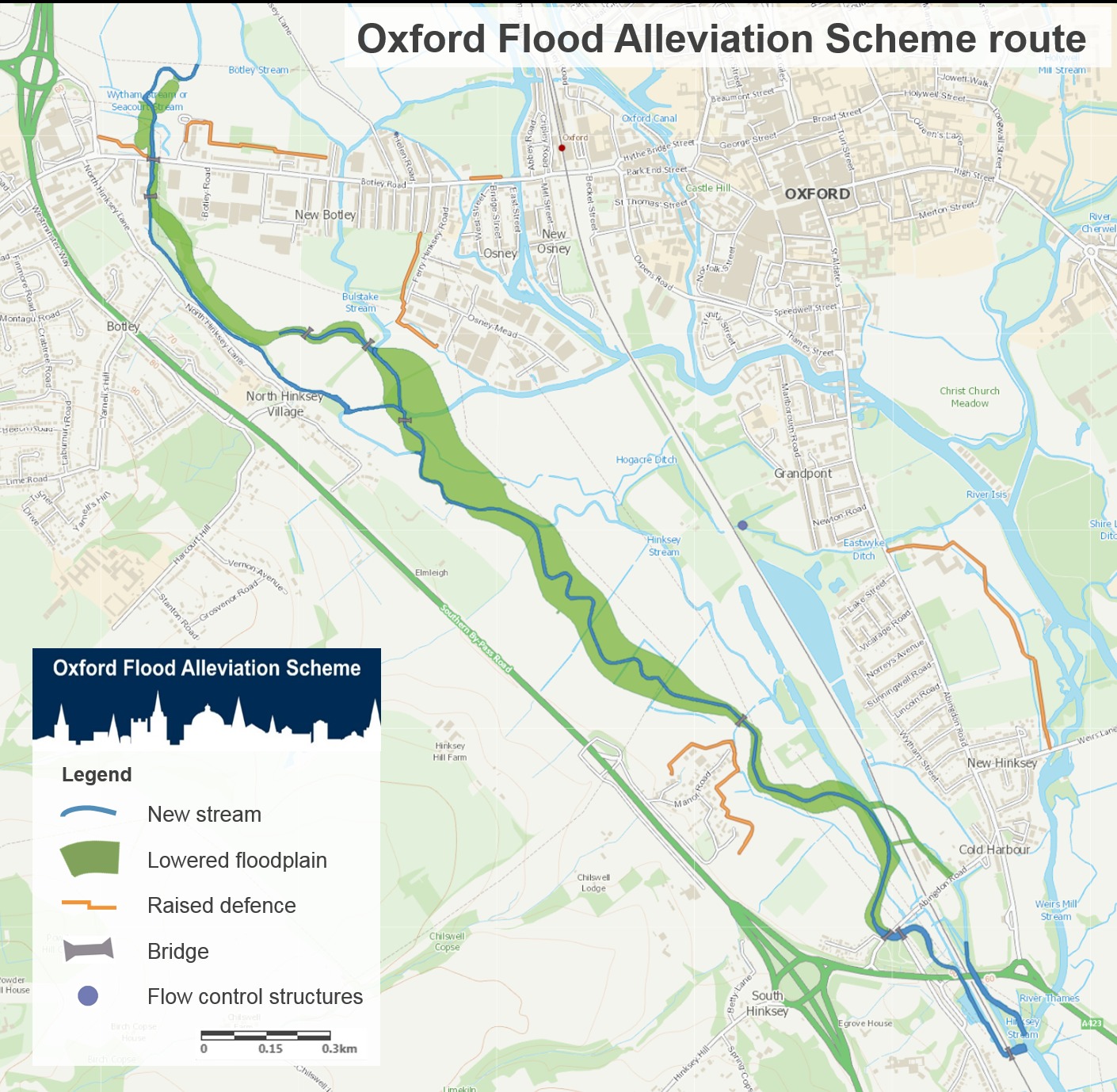
The route of the Oxford Flood Alleviation Scheme. Picture: Environment Agency
Changes to the plan include a new partnership with the environmental charity Earth Trust, who will help to make the newly-dug stream look natural and encourage wildlife to live in it.
Part of the new stream will also be redirected as it runs through the nature reserve Kendall Copse, and a temporary road is planned to ease traffic on Old Abingdon Road.
At the moment, water pumps and barriers are used to protect areas of Oxford from flooding during winter months.
The online consultation into the flood alleviation scheme runs until May 31 and is available at consult.environment-agency.gov.uk/thames/oxfordscheme


Comments: Our rules
We want our comments to be a lively and valuable part of our community - a place where readers can debate and engage with the most important local issues. The ability to comment on our stories is a privilege, not a right, however, and that privilege may be withdrawn if it is abused or misused.
Please report any comments that break our rules.
Read the rules hereLast Updated:
Report this comment Cancel