
THE public can today start having their say on potential routes for a £120m flood relief channel through Oxford.
Plans for the seven-kilometre drainage system will be unveiled by the Environment Agency at Oxford Town Hall from 2.30pm in the first of a series of consultations.
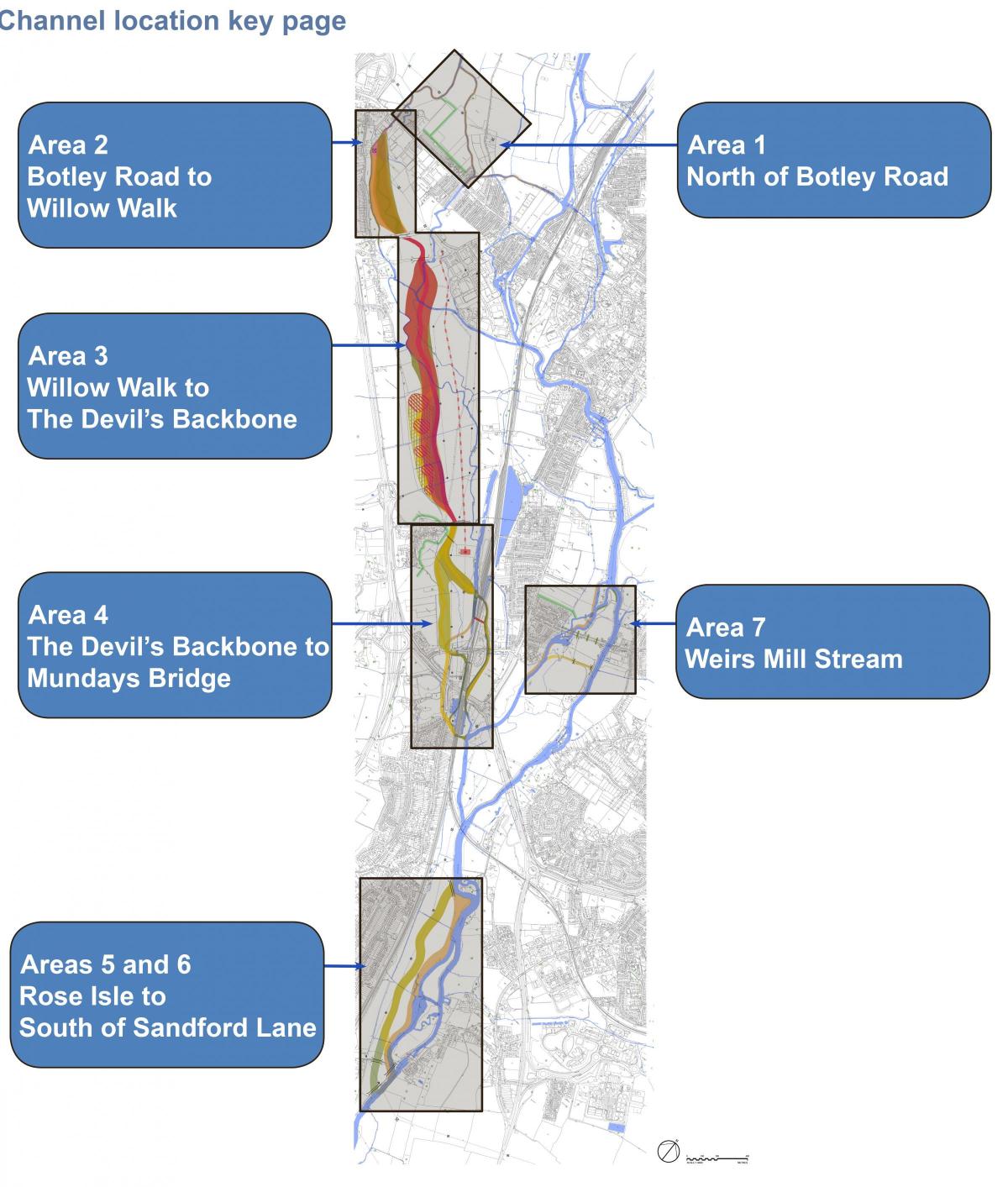
The route has been split into seven areas, with each having a number of options.
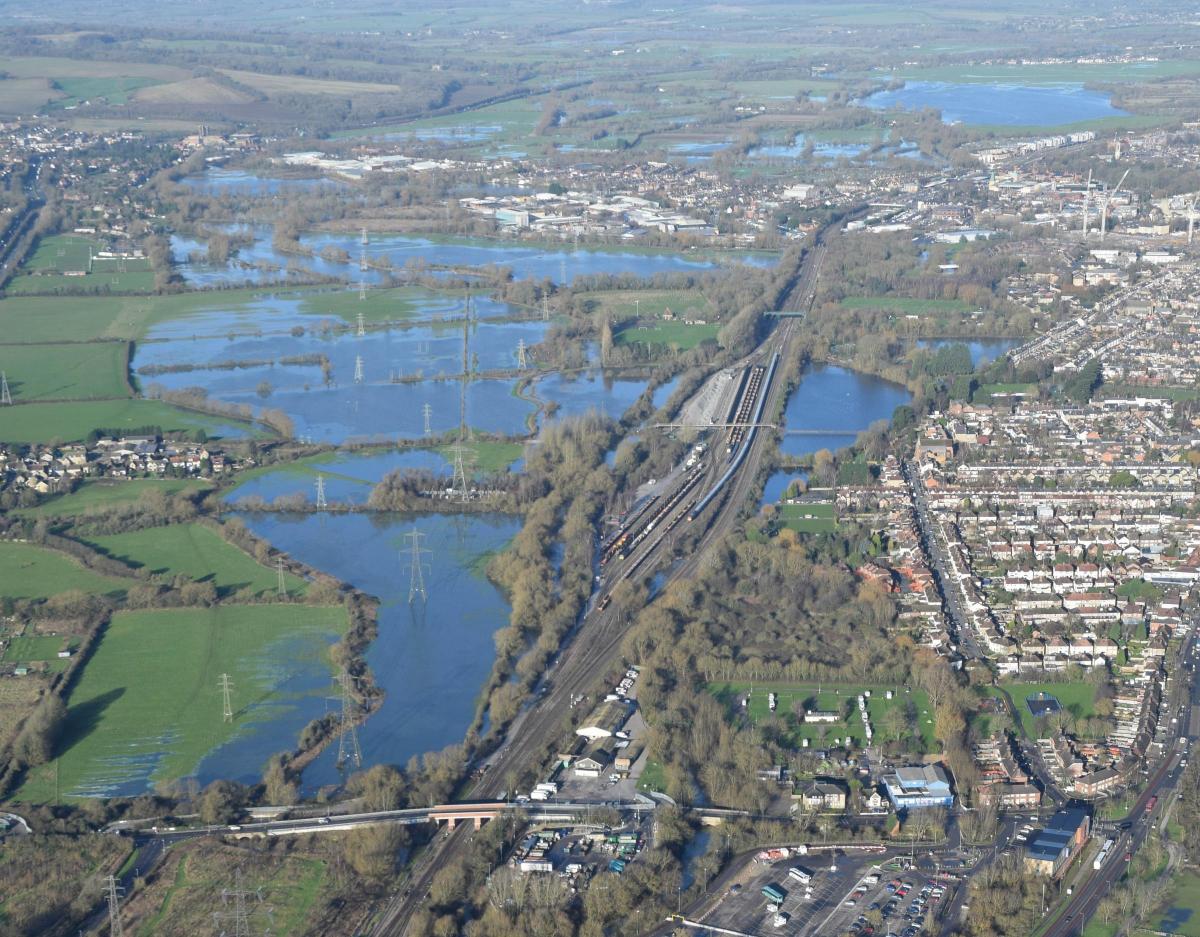
The channel, which could be as wide as 150m in places, will run from Seacourt Park-and-Ride in Botley Road past Willow Walk and on to the Devil’s Backbone – a path which leads to South Hinksey.
The village would also have a localised flood defence system around it as part of the scheme.
The route will continue through Oxford’s western floodplain to Munday’s Bridge in Kennington and then cross the railway near Redbridge Park-and-Ride before splitting into two and rejoining at Sandford Lock.
The precise width, depth and location of the channel has not yet been decided.
Deputy leader of Oxfordshire County Council, Rodney Rose, said: “Plans for the flood alleviation scheme are progressing well, and now is a good time to share all the work that has been done since the public events last summer.
“We are encouraging local communities, residents and businesses to take this opportunity to get involved in influencing the development of the scheme and have their say on the different options for the route.”
Oxford Flood Alliance chairman Peter Rawcliffe, who saw the plans last week, said: “There is nothing too surprising.
“It’s the sort of thing we were expecting, which is good news.”
The depth of the channel will remain around 1m to 2m throughout while its width could vary between 150m – from Botley Road to Willow Walk – and 70m towards Sandford Lane.
It will be a natural channel dug out of the floodplain, making use of existing channels and streams.
It could also split at various points to share the flow of water.
The scheme aims to reduce flood damage to more than 1,000 homes and businesses in Oxford as well as tackling the impact on the economy, roads and railways in the face of major flooding.
The Environment Agency also wants to create a new wildlife habitat and recreational space for watersports.
Three of the four options for the stretch between Willow Walk and South Hinksey include the creation of one or a series of lakes that could be used for this.
It was also revealed the project could include improvements to the Thames Path and the Sustrans cycle route, which runs north to south through the Oxford floodplain.
To view the full list of options in detail and respond to the consultation go to consult.environment-agency.gov.uk Oxford civic leaders hoping to form a new body to manage the flood alleviation channel have met for the first time.
Mr Rawcliffe, who has said the channel would “only be as good as its management”, convened the meeting earlier this month.
He was joined by Oxford city and Oxfordshire county council leaders and representatives from the EA, which is designing the channel.
Mr Rawcliffe said there was “a lot of interest” in forming a local group to manage it.


Comments: Our rules
We want our comments to be a lively and valuable part of our community - a place where readers can debate and engage with the most important local issues. The ability to comment on our stories is a privilege, not a right, however, and that privilege may be withdrawn if it is abused or misused.
Please report any comments that break our rules.
Read the rules here